


|
|
Finding north is easy. All you have to do is look at where the needle in the compass is pointing or look towards the top of the map and you’re
set…Well, not really. While the compass does point north, the compass is pointing to magnetic north. The north listed on the map is known as true
north and it is always a few degrees off. This difference between true north and magnetic north is known as magnetic declination.
|
|
|
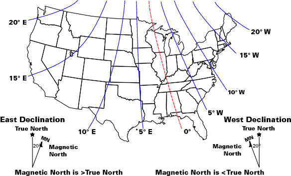
As noted in the image above, magnetic declination differs depending upon where you are standing in the world, and while a few degrees do not sound
much, you can be over 100 ft off every mile for each degree. In order to calculate the most current declination angle for your current location,
visit the National Oceanic and Atmospheric Administration (NOAA) website at:
NGDC Geomagnetic Calculator.
You can also identify the declination of an area with maps. Map manufacturers normally indicate the declination at the
time of the printing of the map. However, while declination changes over time it is also important to regularly check the declination of your location
from an accurate source.
Now that you got the declination, what do you do with it? The declination is given as a degree. The user should either add, or subtract, the
declination degree to 0 so you can identify True North. If you are located west of the Agonic Line, such as Pasadena, then you would subtract
the declination degree from 0 to obtain the map bearing; this is known as East Declination. If you are located east of the line, you would add the declination degree
from 0 to obtain the map bearing; this is known as West Declination. An easy way to determine whether to add or subtract declination would be to look at the map’s
declination value. If magnetic north is located on the right within the legend, you must subtract. If magnetic north is located on the left
within the legend, you must add.
Once this has been done, you can now orientate the map which can be broken down into three easy steps.
- Place the map on a flat surface and adjust your compass with the correct declination degree.
- Set the compass to 0 (North) and place the compass on the map with the base plate parallel to one of the map’s north to south meridians.
- Rotate the map and compass together until the magnetic needle is boxed within the Orienteering Arrow.
- The bearing between the two points is the degree under the Direction of Travel.
You now have an oriented map that you can use while you navigate the great outdoors.
|
|